Wednesday, November 16, 2016

The Great Outdoors Challenge 2017

The Great Outdoors Challenge 2017??

This wasn't supposed to happen.  Doing the Great Outdoors Challenge (TGOC) in 2016 was supposed to be a one-off adventure.  But then I had a blast walking across the Scottish Highlands and met some great people.  So I said, I'll do the TGOC again in 2018 when my friends Kenny and Ava could do the challenge again.  But in September when registration time came around I just couldn't say no.  I applied and got the official notice on November 6th that I have once again been admitted into the Challenge for this coming year!!

Since November 6th, which I know is only 10 days, I've bought new raingear:

Outdoor Research Helium II Jacket

Montbell Versalite Pants

I've also purchased a new (very expensive) tent that I should have saved money up for in advance, but it was on sale and couldn't stop myself:

Zpacks Duplex

I purchased the .74oz/sqyd cuben fiber version, which adds about 2oz to the weight.  BUT, this tent only weighs ~23oz plus the weight of my stakes.  I'm not sure of the actual weight as I haven't weighed it yet.  This drops the weight of my shelter from 3.5lbs with my old tent to about 26 or 27oz.  That's at least a 1.5lb weight loss from one item.  You can expect a full review of the tent pretty soon and at least pictures of the other items. 

Just by purchasing those items I've dropped at least 2.5lbs from last years base weight which was just under 15lbs.  

So needless to say I'm excited for TGOC 2017.  I haven't figured out where I'm starting from or going to yet.

On top of that, I also decided to up the difficulty level for 2017 by doing the 3 Peaks Challenge after I complete the TGOC.  The 3 Peaks Challenge is climbing the highest peak in Scotland, Wales, and England within a 24 hour time frame.  Hopefully my feet are in better shape after the TGOC next year.  More details on both challenges to come!

Tuesday, July 26, 2016

2016 TGO Gear Recap

TGO Gear Recap

A brief review of some of the new gear I used on this trip and also some of the systems I changed for this particular adventure. 

What can I say about this pack?  It's simply the best pack I've ever used.  This was the first long distance hike I carried it on, and it really was flawless.  For starters, the pack is light (about 28oz.), tough, and comfortable.  My max load was around 23 lbs, but it never felt like I was carrying that amount of weight.  This pack just carries weight so well.  Some other nice features are the outside pockets: one on the back, two on the sides, and two on the waistbelt.  I carried my compass, snacks, and camera in the waist pockets.  On the sides I carried a water bottle and my tent poles, and the back pocket I carried my water filter and rain jacket or fleece (depending on the weather).  Another amazing thing about this pack is that it's waterproof.  Now, it can't be submerged because the bottom seams aren't seam sealed, but I went through the Lairag Ghru in driving wind and rain and my pack was totally dry inside and my camera in the waistbelt pocket was dry as well (the rest of me was soaked through).  No more pack cover or trash compactor liner for me again.  The only negative I can think of is that the white color shows mud and dirt stains.  It doesn't bother me personally, since I feel like a backpack should be out there getting dirty.  All in all, this is by far my favorite pack of all time. 

Tent: Big Agnes Seedhouse SL2 (2011 model)
This is an older tent that's nearing the end of it's life.  The reason I'm including it is to talk about how it handled the Scotland conditions as opposed to conditions on the Appalachian Trail or other US trails.  This is a 2 person tent (really more like 1.5 person, but it's the perfect size for me and all my gear and pack to fit in there) and weighs about 3.5 lbs. including the groundsheet and the extra stakes I carried in Scotland for my guy lines.  For the size and weight it was tops when it came out in 2011, now I believe there's some lighter tents.  This is a bomber tent, I've never gotten wet in it, and I don't have condensation problems.  The only issue I've had is a couple tiny pinhole size holes in the floor from pine needles poking through, but that's to be expected from the lightweight material that the tent is constructed of.  The only place this tent is lacking in is the ability to pitch the outer rainfly before the inner.  It seems like all the manufacturers in the UK give people the ability to do this, which makes sense because it's so much wetter over there.  On the plus side, tents manufactured in the US tend to have much more surface area of mosquito netting, which also makes sense since it's typically not as cold in the US.  Other than getting a little wet when pitching the tent in the rain, this was a great tent for use on the TGO Challenge. 

At almost exactly 1 lb (including stuff sack) this is one of the lightest sleeping bags out there.  I just replaced an old 30 degree bag with this one for this trip.  The old bag was definitely on its last legs and not 30 degrees anymore, so I was carrying a liner as well.  All in all, I cut almost 20 oz by purchasing this sleeping bag.  The first night of the challenge the temperature dropped to 29 degrees.  Honestly I didn't even realize how cold it was until I got out of my sleeping bag in the morning as I was toasty warm in there.  This is the first time I've gone without a hood on a sleeping bag, so in addition I used my Turtle Fur Fleece Hat at night. Also of note, the stuff sack included from Z Packs is cuben fiber, so it is also waterproof.


Pillow:  Sea to Summit Aeros Pillow Ultra Light
I needed to replace my pillow as my previous one sprung a leak on the first night of my last backpacking trip.  I know most people use clothes in a stuffsack as a pillow, but I've never been comfortable when doing that.  At 2oz, this pillow is totally worth it for me.  It has a multi-funtional valve.  All that means is it has a large plug with a smaller plug built into the center of it.  If you open the small plug you can inflate it (single direction valve so it doesn't deflate when you take a breath) and when you're ready to pack up in the morning you open the large valve and it deflates quickly.  This pillow is very comfortable.  The only problem I had with it is that the material slides on my sleeping pad easily. 

Navigation Device: Moto G cell phone with OS Locate app installed
I am including this since it's the first time in a while I've needed to do off-trail navigation.  I decided to use my phone as my backup navigation device (primary was paper map and compass) rather than a dedicated GPS.  I put the phone on airplane mode, which still allowed me to get the GPS reading quickly.  I would have to say that when compared to people with their dedicated GPS devices, my phone got the coordinates roughly 3 times as fast.  And it was always accurate.  So rather than spend money on a GPS device for the UK, just download the OS Locate app. 

Monday, July 25, 2016

2016 TGO Stats

Some stats from my TGO Challenge 2016


Total Miles: 176 miles
Highest Elevation: 3330 feet (Beinn Fhada)
Total Ascent; 23,924 feet (according to OS Maps)
Days Taken: 13
Zero Days: 1
Average Daily Miles:  14.58

Final Route KMZ downloadClick this link if you would like to download my final route for use in Google Earth.  Just remember the route may not match up exactly in Google Earth as I used different software to actually plot my route.

Full Route
Elevation profile

Post 2016 Challenge Day 14

Post Challenge: Day 14

Montrose
Thursday, May 26th, 2016

This was originally the day I was scheduled to finish, so it was a relaxing day in town for me.  After saying goodbye to Kenny and Ava as they headed home, I relaxed in my room for a bit before showering again and heading over to the campgrounds to set up.  

Montrose Campground -- I forgot to take a picture until it was almost nighttime
A street in Montrose
Another picture from my wandering around town
After getting settled I spent the afternoon wandering around town a bit and chatting with people I had met on my crossing at the campsite.  About 5pm I got ready for the big Thursday night dinner (and as a bonus, there was also a wedding before the dinner).
The wedding taking place
During the award portion of the dinner


2016 TGO Challege Day 13

2016 TGO Challenge Day 13

North Water Bridge to Montrose (8.25 miles)
Total Trip Miles:172.75
Wednesday, May 25th, 2016
Day 13

The final day had finally arrived.  I woke up with excitement for the end but also a sadness that this journey would soon be over.  I made sure to get a good picture of Kenny and Ava as I realized we'd never actually taken a good shot even though we'd been talking about it since day 3, I believe.   
Me on the final day

Kenny and Ava
We walked through more farmland along the B roads to get to the coast.  Honestly, it wasn't very exciting, and the thing that kept us going on our aching feet was the finish line.  
I like the contrast of the bright yellow and gray skies

Our first view of Montrose
All of us at the sign heading into town
Once we got into Montrose, we took a wrong turn and headed way into town and then had to head back north and cross a golf course to get to the beach.  
The North Sea!!


The wind was so strong that after 2 minutes our writing was already fading away
After taking some pictures we quickly got out of the freezing wind coming off the North Sea. We headed off to find the Park Hotel, where our crossing would officially be over when we signed out.  
The true finish line!
We received a warm welcome from the challengers in the control center room of the hotel.  We all signed out and received our bag of loot.  We hung out for a bit eating some snacks and chatting with the other challengers.  

Kenny and Ava had a room booked into the hotel (they were doing the Wednesday night dinner and then heading home the next morning).  After they got showered in their room Kenny went to urgent care (actually called something else over there, but I don't remember what they called it) where he had a giant piece of skin cut off from his heel and got his wound professionally dressed.  Just as I was about to head out of the hotel to head over to the campground I heard that one room had become available.  Another challenger, Phil, happened to be sitting in the lobby and we decided to splurge a bit and split the room for the night.  

I showered, got some dinner and then watched TV until I passed out.  The perfect end to a challenge, I think.

2016 TGO Challenge Day 12

2016 TGO Challenge Day 12

Tarfside to North Water Bridge (16.75 miles)
Total Trip Miles: 164.5
Tuesday, May 24th, 2016
Day 12 part 1

Day 12 part 2

We decided to do our whole route roadwalking today to spare both my feet and Kenny's.  Basically the whole morning we were descending as we came out of the mountains into farmland that would eventually lead us to the coast.  Our goal for the day was North Water Bridge campsite by way of Edzell where we knew we could get a hot lunch.
The blue door route -- unfortunately not taken

You can see how high the floodwaters made it this past winter
Farmland

We arrived in Edzell a little late, about 2pm, for lunch.  We also made a stop at the chemist shop to get some supplies to tend to our blister wounds.  We were going to hang around town a bit, but our feet were hurting and we just wanted to get on with the walk to the campsite.
Edzell kitty -- always watching

The final 3 miles or so was on a perfectly straight piece of road.  Part of it went along an old airfield the US military used to use, but is now abandoned.
Long, straight roads

After arriving at the campsite we quickly got our tents set up (and dried out) and hit the showers (seperately).  After that we hung out with the 20 or so other challengers that had come in.  We would all be finishing our crossing the next day!!

Tuesday, July 19, 2016

2016 TGO Challenge Day 11

2016 TGO Challenge Day 11

Ballater to Tarfside (16.75 miles)
Total Trip Miles: 147.75
Monday, May 23rd, 2016
Day 11 part 1
Day 11 part 2
We left the Ballater campsite around our normal time, about 8:15am.  Between my blisters and Kenny's blisters, we were moving pretty slow.  Once out of town we had a chunk of somewhat level terrain.  The pain from my blisters subsided a bit the longer I walked on them, but it never went away totally.  

Just over a mile into our day we had a climb up Pannanich Hill.  It was basically straight up the hill.  It took us a long time.  My feet hurt and Kenny was really struggling with the blister on his heel.  We took a short break at the top of the hill and Kenny decided he couldn't continue in his boots so on went his Keen sandals.  Luckily they were pretty rugged sandals with a closed toe and a strap along the back.  He could feel every rock he stepped on though.  He also got a new nickname, Jesus Sandals, even though they were not really Jesus sandals.  
Jesus Sandals sighting!  Thanks to Ava for the pic!

View from the climb up Pannanich Hill

View from the climb up Pannanich Hill
Statue on the top of the Hill

Panarama from the top of the hill, Mt. Keen almost center


From the top of Pannanich Hill we had about 4 miles to get down to the Shiel of Glentanar.  Looking at the map it seemed as if this would be easy cruising, but it turned out to be anything but.  The map shows a LRT for the first couple miles, and while there was a pretty good track to follow there were a lot of different tracks going multiple directions.  We often had to guess which was the correct track and when we were wrong we'd have to cross bog to find the correct one.  After a time we turned off onto a small track that half the time faded into a mostly invisible line of gently pushed down grass.  Added to that I was constantly in pain from my blisters whenever I stepped on uneven turf.  Kenny was also doing his best to avoid water/mud as he was in sandals.  
Kenny and Ava heading down into Shiel of Glentanar with Mt. Keen looming above
We got down to Shiel of Glentanar around 1pm and stopped for lunch at the bridge over the Water of Tanar.  This means we did 5 miles in 4 hours, or 1.25 miles per hour.  Not good considering we had almost 12 more miles to do.  

After lunch we had a 1,200 ft climb over about 1.25 miles up to the bypass of Mt Keen.  My original plan had been to summit Mt. Keen but seeing as I was in a pretty good amount of pain (and the weather wasn't great)  I decided to do the bypass as well.  
Looking back down into Shiel of Glentanar from the shoulder of Mt. Keen before the bypass
The trail down from Mt. Keen was pretty rocky and made for more slow going for me and Kenny.  Ava was limping because her knee was bothering her, but she was in the best condition by far.  The rain came down again as we made it down into Glen Mark.  From Glen Mark we figured it would be a pretty easy walk into Tarfside, but we were wrong again.  
Looking down into Glen Mark from Mt. Keen
The path down to Glen Mark right before the sky opened
 There was lots of water on the LRT and we spent a good amount of time and energy avoiding it.  We also had two raging rivers to cross that weren't on the map (or there when Kenny and Ava had summited mt. Keen previously).  One of them we had to throw our packs across and then leap across the quickly moving water.  After an already long day having to figure out how to cross two fast-moving streams at the end of the day was exhausting. 
The Queen's Well in Glen mark (this is Ava's picture taken on a previous trip. I had put my camera away due to the inclement weather)
We eventually made it to the parking lot at Auchronie and the final push to Tarfside.  This last leg was a nice jaunt through sheep pastures, but we were all so exhausted from our long day that this section felt like it took forever.  By the time we made it to Tarfside we must have looked exhausted because multiple people commented how spent we all looked.  


At Tarfside a hiking club cooks hot meals and run a little hostel for the challengers (all the money raised goes to the hiking groups).  The hostel was full, since noon apparently, and we missed both sittings of dinner.  The volunteers were nice enough to let us eat at the third sitting with them, and 4 or 5 other challengers who came in late also joined us.  The town also lets the challengers use their sports field as a campground so that's where we slept.  We stopped in at the little pub they open for challengers but we were all so exhausted we only stayed for 5 minutes...plus it was cramped and hot in there. I was alseep shortly after my head hit my inflatable pillow.

Tuesday, July 5, 2016

2016 TGO Challenge Day 10

2016 TGO Challenge Day 10

Planned: Braemar to Glas-Allt-Shiel (13.5 miles)
Actual: Braemar to Ballater (18 miles)
Total Trip Miles: 131
Sunday, May 22nd, 2016
Day 10 part 1

Day 10 part 2
 I met up with Kenny and Ava at 8:30am outside my hotel to begin our walk out of town.  We headed north on the Old Military Road which took us past Braemar Castle.  
Braemar Castle
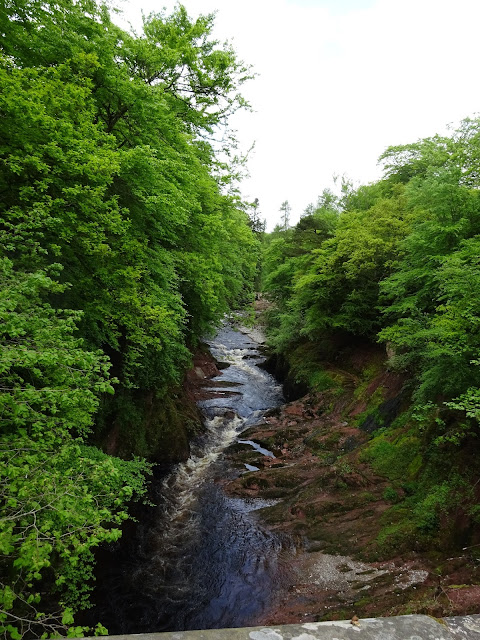
View along the road

We followed the road for just under 3 miles, and we realized most drivers don't move over or slow down for people walking along the edge of the road.  I was also having weird pain/tightness on the front of my left ankle and running down the top of my foot.  It was slowing me down a bit, but once we got off the road into the Ballochbuie Forest my foot started to feel better.  I'm guessing it was something to do with the hardness of the pavement first thing in the morning.  At Garbh allt Shiel we noticed a land rover parked by the lodge with a bunch of people watching some deer that were walking through the meadow.   


After a few more miles we came to Connachat Cottage in the middle of the forest.  It had a monument across from it.  I'm not sure what it was for, maybe someone reading this has an idea?

Connachat Cottage

Monument
Close up
The track through the forest


The gang on the path to Balmoral Castle


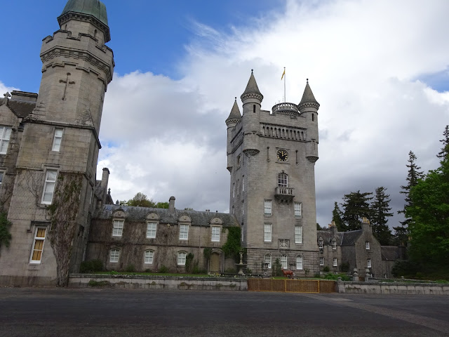
We continued on the LRT through the wilderness and started to run into quite a few other challengers.  We ended up hiking to Balmoral Castle with Doug, Dorothy, and another hiker named Brian.  Balmoral Castle is where the royal family stays when they're in Scotland;  there were quite a few tourists there on the grounds when we stopped in.  We took a nice break in the cafe for lunch and some internet usage while we had it.  
There was some sort of race going on on the castle grounds
Balmoral Castle
Boar statue

Balmoral Castle garden


After lunch turned out to be a roadwalk the rest of the way into Ballater, about 9 miles.  It was a pretty warm afternoon, and I kept getting the same burning feeling on the balls of my feet that I had on day 3.  I did stop once to take my shoes and socks off to let my feet air out, but I didn't see any blisters forming.  I should have taken further steps because, as I would find out that night after arriving in Ballater, I had nice big blisters on the balls of both feet.  

The rest of the road walk was pretty uneventful.  We walked on the road through forest, past some random monuments, and through lots of pastures with sheep.  Other than the pain in the balls of my feet it was a pleasant walk...until we were about half a mile from Ballater and the skies opened up with rain, thunder, and lightning.  I was soaked through almost immediately.

On the side of the road


Ba ba black sheep
We finally made it into town and paid for our stay in the campsite (after waiting most of the rain out in the office), and pitched our tents for the night.  It also turned out that Kenny had a pretty nasty blister form on one of his heals over the course of the day.  His blister had started from his boots before Braemar so he purchased a new pair in Braemar.  Unfortunately the new boots just seemed to make it worse. 

Kenny and Ava walked to the fish and chip shop further into town, but my feet were hurting so I opted to just stay in my tent. I ended up taking a long nap.  When I got out of my tent most everyone else had turned in for the night, but I was just getting up to make myself dinner.  After a hot meal I turned in for the night.  
Fog over Ballater

Tent city at Ballater campground